3ºESO. Orienteering 1: The basics
Orienteering is a sport that requires navigational skills using a map and compass to navigate from one point to another in unfamiliar terrain.
Participants are given a map, usually a specially prepared orienteering map, which they use to find control points. It was originally a training exercise for military officers, but it has now become a federated sport.
The International Orienteering federation recognises four types of orienteering:
→ Foot orienteering
→ Mountain bike orienteering
→ Ski orienteering
→ Trail orienteering ( in wheelchair)
But many times, orienteering is included in adventure raids or mixed with other sports, as horse riding or canoeing.
The Map:
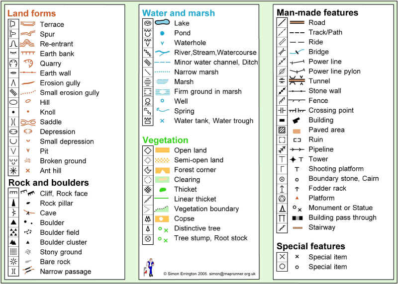
Orienteering maps are very detailed topographical maps (they show hills and valleys). Their scales are 1:15,000 or 1:10,000, wich means every cm in the map equals 15.000 or 10.000 cms (150 or 100m) on the terrain. Map symbols are standardized by the IOF, and designed to be readable by any competitor.
The orienteering course is marked in purple or red on a map. A triangle is used to indicate the start and a double circle indicates the finish. Circles are used to show the control points.
Every other part on the map (rivers, roads, etc) has a specific colour.

Image: www.cuerpoymovimiento.com
Map colours:
(extracted from www.williams.edu)
 Black symbols are used for rock features (for example, boulders, cliffs, stony ground) and for linear features such as roads, trails and fences as well as for other man-made features (for example, ruins and buildings)
  Brown symbols are used for landforms such as contour lines, small knolls, ditches, earthbanks.
  Blue is used for water features: lakes, ponds, rivers, streams, marshes.
  Yellow is to show vegetation - specifically for open or unforested land. The density of the yellow color shows how clear the area is: brightest yellow for lawns, pale yellow for meadows with high grass.
  Green is used to show vegetation that slows down the passage of an orienteer. The darkest green areas, called "fight", are almost impassably overgrown.
  White on an orienteering map signfies forest with little or no undergrowth - forest that an orienteer can run through.
  Purple (or red) is used to mark the orienteering course on a map. Conditions that are specific to an event (such as out-of-bounds fields in which crops are growing) are also designated in red or purple.

Image: www.williams.edu
Controls:
Control points are marked in the terrain by white and orange "flags".

Image: Kharker @ Wikimedia Commons
Control card and punching:
Each competitor must carry a control card, and has to present it at the Start and hand it in at the Finish. The control card is marked at each control point to show that the competitor has completed the course correctly.

Image: Una Smith @ Wikimedia Commons
(Usually with needle punches, but most events now use electronic punching).
A needle punch:
Image: Oriel @ Wikimedia Commons
Results:
The winner is the competitor who has found and passed through all control points with the fastest time.
You can see an orienteering race using electronic punching in this video:
There are maps on the bottom sides to show you how the racer is progressing from one control point to the next one.


